

|
|
|
|
Chase Reports Summer 2002/03 Summer 2001/02 Winter 2001 Winter 2000 20/06/00 - Winter chase, 3 Tornadoes Summer 1999/200020/02/00 - Thundery showers in Perth Jan 4-14, 2000 Dust Devil Paradise 24/12/99 - Christmas Eve Chase 29/02/99 - Chase North East, nice storm with gust front 11th,12th,13th/12/99 - Chase's to Perth coast, Bindoon & Toodyay 02/11/99 - Nice chase to the wheatbelt with numerous CB's & some great mammatus Winter 1999 Summer 1998/1999 28/11/98 - Dowerin Tornado & chase Winter 1997/1998 17/04/98 - I chased & saw my first tornado, 2 supercells an awesome wallcloud & 1-2 inch hail Winter 1997 05/09/97 - 5 tornadoes in WA in 36 hours Summer 1996/1997 |
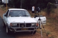
All images © Inflow Images
All images © Inflow Images
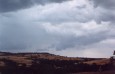
Chase Reports for the 11th / 12th & 13th of December 1999.
Well we had been watching conditions build for a few days but the AVN runs were all over the shop. The basic summary was that we had a trough off the coast. A mid level feature came into play but and confused us all as to exactly what this would do. It was evident that the BOM also weren't sure cause they took an extra hour on Saturdays forecast. Anyway at first it looked good for the whole weekend and Monday also. We rose on Saturday sort of planning to go towards Geraldton but it never really looked that good and we decided that staying in perth was our best bet. Around lunch the BOM went for a *STA for the Geraldton area but it had me buggered, I spent the whole morning going over charts and I couldn't see anything in the area at all. There were some very small cells inland and a few hours later the STA was withdraw for Geraldton but keep for inland areas. We never saw anything on the radar that looked that good. Around 3:00ish it started to fire to the north of Perth off the coast so Mark and Greg headed to the coast at Scarborough whilst I picked up John and we met them there. A storm tracked parrel to us down the coast and we got a nice lightning display. We got a few real nice CG's on video. We tried to move south with it but it must have seen us coming cause it went into top gear and just took off! We had no chance of keeping up with it. So we headed back to Marks place to get a radar update. We saw a few small cells around that were active with lightning but not many opportunities for photos so John and I headed home.
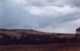
Sunday the 12th
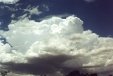
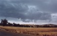
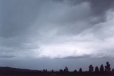
Sunday was to be the better day and we rose, checked things out, John and I were joined by Mark and Greg and then we all headed off at about 11:00am. As we got onto the freeway there was Alto-cu going up everywhere and over the hills small cu had started. Now considering the forecast we were going by was storms for 31S which is the Lancelin area about 2hrs north of perth I was like, mmmmmmmmmm. Looking towards Lancelin basically there was no development at all. AVN doesn't deal with our scrap too good. We stopped just north of Wanneroo as 18mths in the UK had given John a hankering for some strawberries. As we stopped to buy some I noticed some towers going up. We drove up the road a bit further and stopped to observe them. They were going up quite fast and had nice dark bases. There was lots of scud and cloud tags along the inflow/outflow boundary on the cells so we got some footage and pics here. The cells weren't reaching great heights so we decided to head a little further north to see what we could see. John and I did comment that we thought AVN was out and what we were just watching was "the" area of instability. I hate driving away from stuff like that.
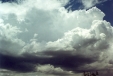
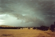
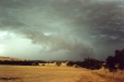
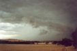
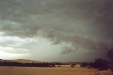
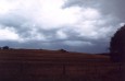
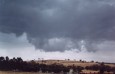
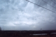
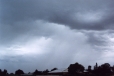
About half an hour later of driving it was evident we were right cause there was nothing to the north. We phoned Jacob for an update and he told us there was a cell inland near Dalwallinu showing green. Although this is like 300ks away I thought by the time we cut across inland we might be able to cut it off. The stuff we drove past earlier was too far away now and we had no hope of catching up with it. So for about the next 1 1/2hrs we had to play catch up. The first time we got a look at the cell it was well south of Dalwallinu and it did look good. It had a suspicious lowering that we stopped to photograph, we couldnt see the whole cell at this stage and it turned out to be along the gust front. At this stage we couldn't see the whole cell. It took a while to get into position as the storm was moving in from our left fast. We came out on a road and I just kept going forward until we were right alongside where the guster would pass. We got out and got some great pics and footage of it. Boy it had some motion. We retreated to the cars as it went past and got some small debris as it passed. The guster winds were approx 90kph I spose. At this point the cool air really took over the cell and the rain widened out and intensified as the guster died. Nice to know we caught it at its best anyway. We tried to catch up and stay ahead of it but the storm was moving way too fast and driving was hard. Heavy rain was now falling and there was allot of debris on the road. I decided to stop as there was no point going south now. We stopped and watched another cell forming to our west and north. It had allot of scud action and some nice lowerings but never showed any rotation at all. Still we got some nice pics. The rest of the day can be summarised by saying rain, rain, more rain, ooooooo a CG!, more rain, rain, CC! etc. We did a big loop down to Toodyay where a phone call to Jacob confirmed the bad news. Basically it had just turned into a big rain band. We headed home via Northam after covering about 350k's. The day did have good shear but what killed it was too much moisture. When there is like 7/8's mid level cloud cover at 10:30am it doesn't give the sun much of a chance to break through and get any decent convection going. AVN was all over the place with this trough but the telling sign pointed out to me by Ben Quinn was the rain fall charts. Its a good tip too, cause it was saying there would be allot of widespread rain for inland. Which is what happened. Next time ill be having a peak at it along with all the usual CAPE, LI's and that.
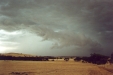
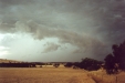
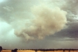
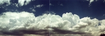
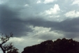
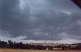
Below are some interesting outflow type features we saw on the way home.

Monday the 13th
The next day had a similar forecast. John and I decided to go for a drive anyway but it turned out to be just more of the same really. We went just north of Perth and found a cell that was dropping some CG's so we set up and just watched it for about half an hour or so. It was pretty average, allot of rain and not much to see. We did a loop inland to Pearce and then back down towards Perth, Just north of Perth we did see a reasonable cell moving in and we stopped for some pics and video for about another half hour or so. After a while it started raining heavy and with not allot else around we headed home after covering about 150k's. All in all not great storms but we got to see a few nice features along the way and got to chase 3 days in a row. Total chase K's for the 3 days was 550K's which only equals about $15 fuel each.
Many thanks once again to "base control" Jacob for his radar updates :-)
*Severe Thunderstorm Advice.