
|
|
|
|
Chase Reports Summer 2002/03 Summer 2001/02 Winter 2001 Winter 2000 20/06/00 - Winter chase, 3 Tornadoes Summer 1999/200020/02/00 - Thundery showers in Perth Jan 4-14, 2000 Dust Devil Paradise 24/12/99 - Christmas Eve Chase 29/02/99 - Chase North East, nice storm with gust front 11th,12th,13th/12/99 - Chase's to Perth coast, Bindoon & Toodyay 02/11/99 - Nice chase to the wheatbelt with numerous CB's & some great mammatus Winter 1999 Summer 1998/1999 28/11/98 - Dowerin Tornado & chase Winter 1997/1998 17/04/98 - I chased & saw my first tornado, 2 supercells an awesome wallcloud & 1-2 inch hail Winter 1997 05/09/97 - 5 tornadoes in WA in 36 hours Summer 1996/1997 |
All images © Inflow Images
Tornadic events for Friday September 5th 1997.
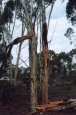
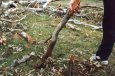
The day started with a severe thunderstorm advice warning issued for coastal areas at 8am. A severe low crossed the coast at around 10am. I was working in Fremantle and John was in West Leederville, which is right near the centre of Perth. I experienced some squalls but nothing too severe. I phoned John at around 10am to see what he could see from his position and he was getting some winds gusts he estimates to be up around 60 knots, gutsing from all directions before the front crossed. We didn’t think at the time that it was worth a drive as winter events are basically guesswork anyway and so decided against it. The severe thunderstorm advice warning for Perth was withdrawn at 10am. Its seems however that a severe storm worked its way inland and the York and Chidlow tornadoes were spawned from this storm at around 11am Towards the evening a second front passed over the coast and headed inland. John was on his way home from work and took several excellent photos of a kind of multi-cell front as it passed over him. The low moved inland and winds in front of the low seem to be in a southeasterly almost easterly direction while winds in the low were obviously southerly. Basically where the winds converge is where the tornadoes occurred. That’s about all the info we have. Unfortunately radar images were taken but are unavailable to us at this time.Tornadoes were reported at Gnagarra, another at Chidlow. The Chidlow Tornado did some minor tree damage and two houses were damaged by debris. We have not been to investigate this track as it was cleaned up straight away and the Bureau told us there was not a lot of damage anyway but that It definitely was an F-0 Tornado, the path was 1.5k's long by 200m wide.
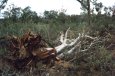
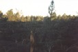
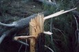
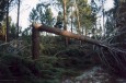
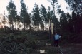
The Gnagarra track was only discovered last Saturday, the 20th. It seems to be the largest. This tornado occurred at approx. 6:00pm in the evening and seems to be of a separate storm than the Chidlow and York events. This tornado is out of the front that John photographed at 5pm in Perth. The tornado touched down in a pine forest about 40k's north of Perth. It is 3.5k's long and about 100m wide. The track is generally in an easterly direction but it does change direction quite a bit with two 90 degree turns, one left and one right. John and I walked up to the touchdown point and right from there the damage is extensive. It doesn’t kind of work into it like the York track. It's there straight away. 99% of the trees in the track have been snapped off around 3 to 4 feet high. This is a pine plantation and the damage just looks like a large bulldozer has been driven through, its quite awesome to stand in a spot and see so many trees down with such a defined edge to the track. There is so much evidence of rotation that it's not funny. Trees are down in all directions and we found branches about 200m back in the forest. One tree has the front half of the tree to the left and the back half pulled of to the right. At the end of the track branches and various other debris were found 2k's away in a paddock. These are only soft wood pine trees but we found several larger trees and they were still snapped off like the smaller ones. The length of the track is also a credit to its strength plus the tornado also had to climb two ridges and kept itself going for quite a distance. We rated it as an F-1.
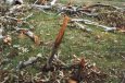
The York track is only about 1k long and about 300m wide, an F-0.
A fourth tornado was observed down south near Ravensthorpe. The man who witnessed and photographed the Northam tornado was the lucky observer. When I phoned him to get a description of it he told me of a friend of his who is also a farmer who watched a tornado touch down in an open paddock next to him and then move on up through the paddock the day before. No damage estimates are available but it was recorded as an F-0 by the bureau. That makes five tornadoes in 36 hours! That we know of. Not bad huh.
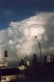
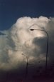
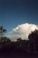
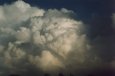
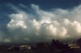
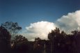
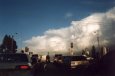
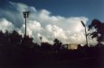
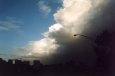
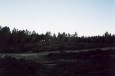
Johns photos of the 5pm CB's on the front as it passed through. With excellent top heights these are great examples of severe winter thunder storms.

Photos of the Gnagarra Tornado track through the pine forest.
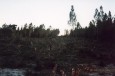
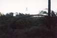
Photos of the damage path of the York Tornado.